Contrail avoidance — detect the pixels, decide the reroute
This is applied ML for a real domain: aviation's contrail climate problem, as EUROCONTROL frames it in its Contrail Avoidance (COAV) work out of Maastricht. Two repositories, built to mirror the two halves of that problem — both runnable, both honestly scoped.
The two halves
- Detect —
contrail-segmentation-demo. A neural-network image-segmentation app: React + TypeScript front end → Node.js (Express) BFF → Python FastAPI service → a hand-written PyTorch U-Net. Pick or upload a sky image; it returns the contrail mask, the coverage %, and the count of distinct contrails. Three services that come up withdocker compose up, with CI on GitHub Actions. This mirrors COAV's Sky Cam Vision™ / Sky InSight™ → ML-detection pipeline. - Decide —
contrail-avoidance-pipeline. A Polars/Pandas pipeline plus a Databricks-style notebook that flag which flights form persistent, climate-warming contrails — using the Schmidt–Appleman Criterion and ice-supersaturated regions (ISSR) — and propose altitude changes, weighing avoided climate forcing (CO₂e) against extra fuel burn. This mirrors COAV's per-flight avoidance trials.
The honest part
Both run end-to-end on a laptop, because both train and run on synthetic-but-physically-plausible data — a synthetic sky generator for the segmentation model, a seeded weather grid and flight tracks for the pipeline. That is a deliberate choice so the whole thing is reproducible in minutes, and each README is explicit about it. The physics (SAC ∩ ISSR) is real and correct in direction; the architecture is the one you'd actually run. Each repo writes down the line between the demo and production — real GVCCS / Sky-Cam imagery and instance tracking on one side, ERA5 reanalysis + OpenSky flight data on the other.
The pattern behind it
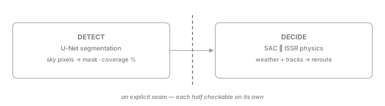
Perception and decision split at an explicit seam. The tempting shape is one end-to-end model from camera pixels to reroute advice — impressive in a demo, impossible to validate: when the answer is wrong you can't say whether it saw wrong or reasoned wrong. Here the problem is cut where the domain cuts it: a perception half that turns pixels into a mask and a coverage number, and a decision half that turns weather and trajectories into a reroute — joined by a small, inspectable interface.
Two decisions carry the pattern:
- The seam is a checkable artifact. A mask and a coverage % can be scored against ground truth on their own; a reroute can be replayed against the physics (SAC ∩ ISSR) on its own. Each half earns trust separately — which is the only way a safety-adjacent domain will ever accept either.
- Synthetic data as an architecture decision, not a shortcut. Training and running on synthetic-but-physically-plausible data is what makes the whole arc reproducible on a laptop in minutes — and each README draws the exact line where real GVCCS imagery and ERA5/OpenSky data would replace it.
The trade-off is stated in the honest part above: reproducibility was bought at the cost of real-world validity claims — deliberately, and in writing.
Why it matters
The two demos prove the full arc of the job in one place: I can build the full-stack ML product that turns camera pixels into a contrail reading, and the data-science decision that turns weather and trajectories into a reroute with a defensible climate-versus-fuel tradeoff — not just one or the other.
→ See both repositories on the portfolio under Applied ML & data science — these two link out.